
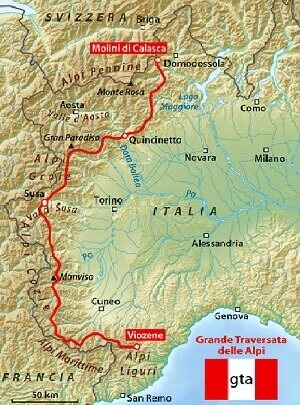
gta
The GTA is the hiking trail linking the Piedmont Alps from the Tanaro Valley to Lake Maggiore with 120 stopover!
Rifugio Rivetti-Sant'Antonio in Val Vogna
Departure (m): 2495
Arrival (m): 1381
Drop (m): 1114
Trekking time: Maccagno pass -Alpe Maccagno: 45m; Alpe Maccagno – Vogna creek: 2h30m; Vogna creek -S. Antonio: 45m; total:4h
Difficulty: medium
Where to eat: Rifugio Valle Vogna
Route number: 205-201 (ex 5-1)
At the Maccagno Pass, trail no. 205 heads down to Lago Nero (2,322 m), where the trail becomes more pronounced and leads to Alpe Maccagno (2,188 m). Continue following the Camino stream that soon flows into the the Maccagno stream; here, the mule track is on the left of the stream and, just before you reach the Alpe Pioda (1,877 m), it moves to the right side of the water course. Here, you find a greater slope descending to Alpe Buzzo (1,718 m) where it crosses the Rio Cortese, wade across the Rio Tillio and you'll reach the wooden bridge crossing over the Maccagno creek that flows into the Solovo which later becomes the Vogna stream. From here, take the no. 201 trail, which passes over a stone bridge and shortly after reaches the S. Grato Oratorio and the hamlet of Peccia (with the first examples of Walser houses). The mule trail now becomes a dirt road and will lead to S. Antonio with a gentle slope.
Sant'Antonio Val Vogna- Rima
Departure (m): 1381
Arrival (m): 1411
Drop (m): 1200
Trekking time: S.Antonio-Riva Valdobbia: 1h; Riva Valdobbia-Pedemonte: 45m; Pedemonte-Z’Ise hus: 1h; Z’Ise hus-Alpe Venghi: 1h15m; Alpe Venghi-Colle Mud: 45m; Colle Mud-Alpe Valmontasca: 1h; Alpe Valmontasca-Rima: 1h; total:6h45m
Difficulty: medium
Where to eat: Rifugio Ferioli (Alagna, Alpe Mud Superiore)
Route number: 209-208-296-291 (ex 9-8-96-91)
From S. Antonio, you'll get to Ca 'di Janzo (1,354 m) in a pleasant walk through the Walser villages, followed by sweeping curves, you'll arrive to Riva Valdobbia, where a 2-km road will take you to Alagna followed by Pedemonte. Here, keeping to the left of the Mud stream, you'll arrive at the foot of the village of Ronco where the mule trail begins and where for a brief part follows Route No. 209. You need to follow Route No. 208 that crosses the over a wooden bridge the Mud stream and continues up a staircase; once you've passed a cliff, cross the brook and continue on a good path that goes along the rib that divides the stream from the brook; after a short time, the sign leading to left will take you to the cottages in Z'Ise hus (1,627 m). Take the route until Alpe Mud (1,887 m). From here, crossing three brooks, you'll come to Alpe Venghi (2,042 m). Once passed the pasture, you'll enter the head of the valley that is dominated by Monte Tagliaferro and the Corno Mud. Here the path goes to the left, leaving the no. 8A trail and continues on a grassland until reaching Colle Mud (2,324 m). It then enters Val Sermenza, the Valmontasca river on the right and the north face of Monte Tagliaferro. The good mule trail, no. 296, passes through the Vorco pasture (2,075 m) and then Alpe Valmontasca (1,819 m). It then follows down through larch trees and turns into No. 291 that reaches a point where you may cross the Sermenza stream entering the town of Rima.
Rima - Carcoforo
Departure (m): 1441
Arrival (m): 1304
Drop (m): 1050
Trekking time: Rima-Alpe Chiaffera: 50m; alpe Chiaffera-Colle del Termo: 2h; Colle del Termo-Alpe del Termo: 35m; Alpe del Termo-Alpe Trasinera Bella: 25m; Alpe Trasinera Bella-Alpe Sella Bruna: 1h20m; Alpe Sella Bruna-Carcoforo: 20m; total: 6h
Difficulty: medium
Where to eat: Rima or Carcoforo
Route number: 293 (ex 93)-112
From the church square, follow the signs for Route No. 293, which winds up on the trail to the left and crosses a stream. The route continues in a zig-zag to lessen the strong tendency, wade the Chiaffera stream and head to the Alpe with the same name (1,706 m). Passing back and forth along the stream with its numerous curves, the trail leads to a ridge. Follow along as it continues in grassland, with a steep climb to the Colle del Thermo (2,351 m). At Route No. 112, it descends into the basin of the Trasinera river and leads to the Alpe Thermo (2,081 m). The trail descends, almost grazing, until reaching clumps of wild alders and near the Alpe Trasinera Vella (1,935 m). Leave this pasture, as the trail enters a larch forest always to the left of the stream, pass the Alpe Sella Bruna (1,464 m). Almost immediately, the trail coasts along the Trasinera. Cross over and follow along the grassland and blueberry bushes. Then goes over the river with the bridge made of concrete pipes. Here the road becomes a dirt track that leads to Carcoforo.