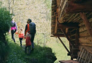
If there is a place to satisfy your desire for hiking, even with snowshoes, that place is Monte Rosa. There are so many trails: short, medium, long, with slight uphill or steep, outdoors in the shade of the woods, following a stream or through the beautiful valleys of Alagna-Valsesia. There is a really wide range of choice, suitable for all levels of experience or age. Just the thought makes you want to put on your boots and go! But be careful: the first rule to enjoy the best hiking experience alone or in the company is knowing the hiking trails. Because there are so many trails and all of them valid, you should know how to orientate yourself, not only geographically, but also in terms of trail selection. A linear path is not necessarily suitable, even for little children, and it is possible that a route at high altitude might be more practical for those who do not have much experience. The important thing is to have a map handy. To facilitate the task, we have prepared one especially for you!
ATTRACTIONS, JOURNEY TIME, VERTICAL DROP AND DIFFICULTY
On the trail map of Alagna Valsesia- Monte Rosa, you will find lots of useful information to organize your adventure hike. For each route we have indicated, in order from left to right, the international numbering, the destination, the altitude, the difficulty, the travel time and what the level of satisfaction is according to our dispassionate opinion. For the level of difficulty, one of the highlights of any hiking map, we used the symbols of the traffic light. 1 green dot for easy trails, 2 yellow dots for medium trails, 3 red dots for the difficult paths. The word "alpine" signals paths that require a significant technical level. We have also reserved a brief introduction to cultural, sport and tips about the communes of Alagna and Riva Valdobbiadene.
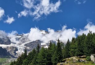
To complete the map, in addition to the streetmap, here are three insights on what we believe are the most beautiful paths to be done in either spring, summer or fall. We are talking about Orteltol (No. 203), a hiking trail to discover the Walser settlements of Otro, rich in natural beauty, cultural, historical and artistic gems. Then there is the Old pass of Colle di Valdobbia (No. 201), from the village of Ca 'Janzo to the refuge Ospizio Sottile at an altitude of 2,480 meters above sea level. Finally the wonderful trail 206 - 206th - 207, dubbed "Under the glaciers of Monte Rosa", an itinerary that runs almost entirely within the natural park of High Valsesia, at the foot of the glaciers that fall down the valley from the south wall east of Monte Rosa. A unique spectacle for both the eyes and spirit!
Download the route map of Alagna - Monte Rosa now!