
The ascent from the Bettaforca pass to the Quintino Sella refuge is a very pleasant and well-marked path that is exciting but not tiring.
From Alagna you will first reach Staffal in Gressoney via cable car and then continue further, still using the cable car, up to the Bettolina pass. From the pass, just beyond the arrival station of the chairlift, trail no. 9 will lead you to the Quintino Sella refuge. The first part of the trail, up to Colle Bettolina at 3,100 m., is an easy and comfortable hike; it becomes steeper and more technical shortly after. It continues higher up along a path with artificial steps and fixed ropes leading up to the ridge which is exposed in some parts but well aided. There is also a small, but sturdy wooden bridge to cross, that facilitates hiking on a particularly tight stretch. The last part of the trail climbs up between 3300 and 3500 m and even though it is often covered in snow from the beginning of the season to the end of July, the trail is generally well-trodden. You must however remember that a phone call to the refuge to ask about hiking conditions is an absolute must.
The refuge Quintino Sella was inaugurated on August 15, 1885. It was a small wooden hut with 15 beds built to be used by alpinists and mountaineers. After being renovated in 1907 it was entrusted to the management of an alpine guide from Alagna, Giovanni Guglielminetti, followed in 1910 by the Gressonari Giovanni, Mariano and Camillo Roveyaz, who took care of the refuge for 60 years and carried out meticulous restoration and conservation work to preserve its cultural heritage. After some structural expansion in 1924, the hut became the reference point for the ascents to Castore and Lyskamm and in 1977 a project for its renovation was launched. This project led Quintino Sella to be what it is today: a refuge with low environmental impact and demonstrating optimal management of such a delicate ecosystem. The hike to refuge Quintino Sella is within the reach of many, however it does require training and the ability to hike on an aided route, but it is a trip that will never be forgotten.
see also suggestions of www.gulliver.it
The TMR (Tour Monte Rosa) is the beautiful route through the villages around Monte Rosa, between Switzerland and Italy, with a circular path.
DOWNLOAD THE MAPThe (TMR ) Tour Monte Rosa is ideally divided into 9 stages starting and finishing in Zermatt. But it can be covered with start and end in any of the villages involved in the tour, choosing the number of stages and direction of travel.
The stages: Zermatt - Theodul pass; Theodul pass - St Jacques; St Jacques - Gressoney; Gressoney - Alagna; Alagna - Macugnaga; Macugnaga - Saas Fee; Saas Fee - Grächen; Grächen - Europahütte; Europahütte - Zermatt
Departure: Zermatt 1616m
Arrival: Colle del Teodulo 3317m
Trekking time: 5,30 h
Reverse path: 4h
Departure: Theodul pass 3317m
Arrival: St. Jacques 1689m
Trekking time: 6h
Reverse path: 7h
Departure: St. Jacques 1689m
Arrival: Gressoney 1637m
Trekking time: 4,30h
Reverse path: 4,30h
Departure: Gressoney 1637m
Arrival: Alagna 1191m
Trekking time: 7h
Reverse path: 8h
Departure: Alagna 1191m
Arrival: Macugnaga 1327m
Trekking time: 8h
Reverse path: 8h
Departure: Macugnaga 1.327m
Arrival: Saas Fee 1772m
Trekking time: 7h
Reverse path: 6,30h
Departure: Saas Fee 1772m
Arrival: Grächen 1619m
Trekking time: 6,30h
Reverse path: 7h
Departure: Grächen 1619m
Arrival: Europahütte 2220m
Trekking time: 6,30h
Reverse path: 5,30h
Departure: Europahütte 2220m
Arrival: Zermatt 1616m
Trekking time: 6h
Reverse path: 6,30h
Gressoney / Gabiet - Alagna
This is one of the longest legs in the trip, but can be shortened using the facilities of the Monterosa ski.
The bronze ibex that overlooks the Gressoney valley from the Camoscio pass, which marks the border between Valle d'Aosta and Valseisa, is without a doubt the objective of the climb from Gressoney, where the vastness of the valley is dotted with numerous Walser pastures crowned by the open, airy spaces of the Gabiet area. Once through the pass, you descend towards Alagna, along a well-marked path in a wide moraine area. After about 30 minutes of descent, you reach the Mosso Institute, a center specializing in research at high altitude of the University of Turin and a bit 'further down the valley is the refuge Vigevano, now closed.
The descent into the valley of Olen runs along Devil's Stone (Sasso del Diavolo), a huge boulder split in two that according to legend, was used by the Devil to prevent the construction of a chapel in Gressoney. But the love of God prevented the crime and the enraged devil threw the boulder towards Alagna and while rolling and bouncing downhill imprisoned the devil inside, where it seems to have remained to this day. Just past the Devil's Stone is the turn off to Foric pass which is chosen by hikers who want to reach Alagna via the beautiful Val d'Otro. For those travelers who pass via Otro, the stop-over is the Tsar Senni refuge in Follu or Alagna with about an hour's walk more. For travelers who decide to hike down to Alagna along the valley of Olen, Alpe Pianalunga can be reached with a 40-minute walk from the path turn-off, where there is a cable car to reach the center of Alagna and 15 minutes downstream is the Grande Halte refuge, another possible stopover point. In another hour and a half you can reach Alagna (see list of hotels and B & B in the accommodation section) or you can continue to Pastore refuge which is the base camp for the next stage. On foot it is about an hour and a half, but in the summer there is a shuttle stop until 5pm (info at + 39 0163 922988). The trip can also be done by taxi at a cost of around € 20 and then a 10 minute walk to reach the refuge that has the most beautiful view of the south face of Mount Rosa
Alagna – Macugnaga
This leg is covered by beautiful paved trails built by the Intra battalion in the 20’s and reaches up to the 2,738 meters of the Turlo -ds Türli pass (the small door – pass), which was used by the Walser of Macugnaga populations to give life to the new colony of Alagna around 1200. The view is wonderful and the ascents are regular and continuous: first forests of deciduous and coniferous trees and on the other side of the vegetation are the Alps and Faller Fum Blatte, which is studded with gentianellas in spring
From the pass you descend into the valley Anzasca and the trail runs through evocative woods and picturesque waterfalls; occasionally you meet ravines and picturesque wooden bridges and also the most exposed sections seem harmless and easy due to a wide, well-maintained trail. Before reaching Quarazza you find the Lake of the Fairies, a small artificial lake that is worth a visit.
From here you can reach Macugnaga in 30 minutes This is a nice Walser village, well organized with many hotels to stay in after this long hike.
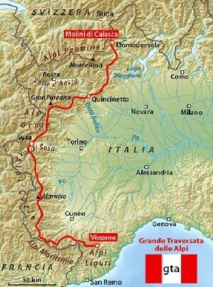
gta
The GTA is the hiking trail linking the Piedmont Alps from the Tanaro Valley to Lake Maggiore with 120 stopover!
Rifugio Rivetti-Sant'Antonio in Val Vogna
Departure (m): 2495
Arrival (m): 1381
Drop (m): 1114
Trekking time: Maccagno pass -Alpe Maccagno: 45m; Alpe Maccagno – Vogna creek: 2h30m; Vogna creek -S. Antonio: 45m; total:4h
Difficulty: medium
Where to eat: Rifugio Valle Vogna
Route number: 205-201 (ex 5-1)
At the Maccagno Pass, trail no. 205 heads down to Lago Nero (2,322 m), where the trail becomes more pronounced and leads to Alpe Maccagno (2,188 m). Continue following the Camino stream that soon flows into the the Maccagno stream; here, the mule track is on the left of the stream and, just before you reach the Alpe Pioda (1,877 m), it moves to the right side of the water course. Here, you find a greater slope descending to Alpe Buzzo (1,718 m) where it crosses the Rio Cortese, wade across the Rio Tillio and you'll reach the wooden bridge crossing over the Maccagno creek that flows into the Solovo which later becomes the Vogna stream. From here, take the no. 201 trail, which passes over a stone bridge and shortly after reaches the S. Grato Oratorio and the hamlet of Peccia (with the first examples of Walser houses). The mule trail now becomes a dirt road and will lead to S. Antonio with a gentle slope.
Sant'Antonio Val Vogna- Rima
Departure (m): 1381
Arrival (m): 1411
Drop (m): 1200
Trekking time: S.Antonio-Riva Valdobbia: 1h; Riva Valdobbia-Pedemonte: 45m; Pedemonte-Z’Ise hus: 1h; Z’Ise hus-Alpe Venghi: 1h15m; Alpe Venghi-Colle Mud: 45m; Colle Mud-Alpe Valmontasca: 1h; Alpe Valmontasca-Rima: 1h; total:6h45m
Difficulty: medium
Where to eat: Rifugio Ferioli (Alagna, Alpe Mud Superiore)
Route number: 209-208-296-291 (ex 9-8-96-91)
From S. Antonio, you'll get to Ca 'di Janzo (1,354 m) in a pleasant walk through the Walser villages, followed by sweeping curves, you'll arrive to Riva Valdobbia, where a 2-km road will take you to Alagna followed by Pedemonte. Here, keeping to the left of the Mud stream, you'll arrive at the foot of the village of Ronco where the mule trail begins and where for a brief part follows Route No. 209. You need to follow Route No. 208 that crosses the over a wooden bridge the Mud stream and continues up a staircase; once you've passed a cliff, cross the brook and continue on a good path that goes along the rib that divides the stream from the brook; after a short time, the sign leading to left will take you to the cottages in Z'Ise hus (1,627 m). Take the route until Alpe Mud (1,887 m). From here, crossing three brooks, you'll come to Alpe Venghi (2,042 m). Once passed the pasture, you'll enter the head of the valley that is dominated by Monte Tagliaferro and the Corno Mud. Here the path goes to the left, leaving the no. 8A trail and continues on a grassland until reaching Colle Mud (2,324 m). It then enters Val Sermenza, the Valmontasca river on the right and the north face of Monte Tagliaferro. The good mule trail, no. 296, passes through the Vorco pasture (2,075 m) and then Alpe Valmontasca (1,819 m). It then follows down through larch trees and turns into No. 291 that reaches a point where you may cross the Sermenza stream entering the town of Rima.
Rima - Carcoforo
Departure (m): 1441
Arrival (m): 1304
Drop (m): 1050
Trekking time: Rima-Alpe Chiaffera: 50m; alpe Chiaffera-Colle del Termo: 2h; Colle del Termo-Alpe del Termo: 35m; Alpe del Termo-Alpe Trasinera Bella: 25m; Alpe Trasinera Bella-Alpe Sella Bruna: 1h20m; Alpe Sella Bruna-Carcoforo: 20m; total: 6h
Difficulty: medium
Where to eat: Rima or Carcoforo
Route number: 293 (ex 93)-112
From the church square, follow the signs for Route No. 293, which winds up on the trail to the left and crosses a stream. The route continues in a zig-zag to lessen the strong tendency, wade the Chiaffera stream and head to the Alpe with the same name (1,706 m). Passing back and forth along the stream with its numerous curves, the trail leads to a ridge. Follow along as it continues in grassland, with a steep climb to the Colle del Thermo (2,351 m). At Route No. 112, it descends into the basin of the Trasinera river and leads to the Alpe Thermo (2,081 m). The trail descends, almost grazing, until reaching clumps of wild alders and near the Alpe Trasinera Vella (1,935 m). Leave this pasture, as the trail enters a larch forest always to the left of the stream, pass the Alpe Sella Bruna (1,464 m). Almost immediately, the trail coasts along the Trasinera. Cross over and follow along the grassland and blueberry bushes. Then goes over the river with the bridge made of concrete pipes. Here the road becomes a dirt track that leads to Carcoforo.